San Diego & Arizona Eastern's Carrizo Gorge
After abandonment following Tropical Storm Kathleen in August, 1976
Carrizo Gorge is a spectacular canyon in the Jacumba Mountains of Southern California, traversed by a spectacular railroad, the San Diego and Arizona Eastern Railway. Though today the name of the railroad has changed (it has gone through the names San Diego and Arizona, Southern Pacific, San Diego and Imperial Valley, and today is called the Carrizo Gorge Railway), the canyon itself has little changed since John D. Spreckels hammered home his golden spike in 1919. The Jacumba Mountains are a desert range, with sparse vegetation scattered in a rust-brown terrain of huge granite boulders lining deep ravines. From the very beginning, the rail line through the Carrizo Gorge was a maintenance nightmare extreme heat and cold, of flash floods from late summer monsoonal thunderstorms, and of tunnels bored through ancient landslides. Two of the original long tunnels, numbers 7 and 15, suffered collapse within ten years after the track was laid, and now have the tracks routed around them on alignments with sharp curves and spectacular wood trestles clinging to the cliffs. Despite these obstacles, through service on the line was fairly continuous from 1905 until late 1976, barring the collapse of tunnels 7 and 15 in 1932. The collapse of tunnel 15 lead to the building of famous Goat Canyon Trestle, 185 feet high and 650 feet long, made of redwood timbers.
In September of 1976, Hurricane Kathleen roared up the length of the Gulf of California between Baja California and the Mexican Mainland, and before it was finished, it dumped a good dozen inches of water on the Imperial Valley of California within only a very few hours. Though reduced to a Tropical Storm as it crossed the border into the United States on September 10, the storm veered to the west and crossed the mountains that separate the Imperial Valley from the Southern California coastal cities of San Diego and Oceanside. The orographic lift given the storm as it crossed the Jacumba Mountains caused a scene of destruction that has meteorologists shaking their heads in amazement to this day. No one is certain exactly how much water fell, however it all came down in an incredibly short span of time, running off the rocks before churning violently down the ravines and canyons. It left one whole side of Interstate Highway 8 along Meyer Creek in In-Ko-Pah Gorge fully missing for several miles, and the concrete bridge at the mouth of the canyon stranded far from any other remaining roadway. It left the center of the town of Ocotillo washed away or buried in sand. The right-of-way of Southern Pacific's San Diego and Arizona Eastern Railway stood in the path of this storm, and was subjected to tremendous flash floods at even small canyon crossings. In many places, the line was either buried in mud, as between Jacumba and Dubbers, or washed away, or huge rocks were undermined by the floodwaters and then fell on the rails. A track inspector sent into the gorge to survey the situation during the storm had to abandon his inspection car when it was marooned between two rock slides; he then had to hike back to Dubbers over several miles of line containing serious washouts with up to an eighth-of-a-mile of rail left hanging in the air.
After the clouds had gone and the floods subsided, Southern Pacific Railroad engineering forces surveyed the wreckage and declared the line finished for good, having sustained $1.27 Million in damage. Three trestles were completely destroyed, and five others heavily damaged. Goat Canyon Trestle itself was sagging in its center span, having had the lower tier of its tallest bent knocked away by a boulder that was sluiced down the canyon by the flood. The fill on the big curve above Tunnel 7 had its center washed away, with a long strand of rails left swinging over the void. Numerous smaller washouts and rockslides blocked the track. Below Carrizo Gorge itself, the line was buried under sand or washed away for many miles, as at the mouth of Meyer Canyon. The line lay abandoned for about five years before San Diego Metropolitan Transit Development Board purchased the line from Plaster City to San Diego. Kyle Railway was given an operating concession. As part of the sale from Southern Pacific, SP rebuilt the line to operating condition. The Kyle managed to reopen the line to El Centro, and for two years ran freight through Carrizo Gorge, before the line once more was closed in 1983, this time by a pair bridge fires and then the collapse of half-mile-long Tunnel 8. Several attempts were made to re-open Tunnel 8 over the intervening years by the San Diego and Imperial Valley Railroad, formed to run the remaining SP lines in the San Diego area after Kyle opted out after 1983. However it wasn't until late in 2003 that the job was finally completed by a new concession, the Carrizo Gorge Railway. It now looks like Carrizo Gorge Railway may start running trains through the gorge on a regular basis from El Centro to the new Toyota auto assembly plant located between Tecate and Tijuana, and perhaps might even run passenger excursions.
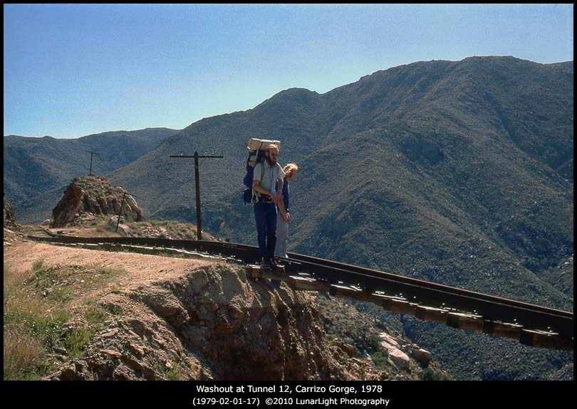
In late 1978, or about two years after Tropical Storm Kathleen raged through the Jacumba Mountains, I hiked into the gorge with my brother and a friend to see both the spectacular canyon and what the storm had done to the line. We started at Dubbers (near Interstate Highway 8) and made it as far as Goat Canyon, carrying backpacks with three gallons of water apiece besides the food and camping gear. My friend Dave Hightower took a number of black and white photos along the way, and I took Kodachromes. The images presented here are a selection from both Dave's and my pictures from that trip. In the short days and long nights of Thanksgiving weekend, we took a whole day to hike down to Goat Canyon, stopping to explore many places during the day and to marvel at the view and at the results of the storm. We hiked through all the tunnels on our route, including half-mile long Tunnel 8. We climbed all over Goat Canyon, looking at the huge trestle and at the north portal of old Tunnel 15, collapsed on March 27 1929, and abandoned after the earth shifted again during an attempt to rebuild it. It was after that event that the big wood trestle (185 feet tall) was built over Goat Canyon, and a shorter Tunnel 15 was drilled at its south end. (Several sources on the internet give the building of the trestle as in 1932.) We camped that night outside the south portal of old Tunnel 15, burning old packing wood from the collapsed tunnel lining in our campfire. We marveled at the tremendous number of huge redwood timbers (something like 16 x 18 inches in dimension, and tens of feet long!) lining the abandoned tunnel, as well as all the other tunnels we had seen. That night we were treated to a sky so clear and dark that the Zodiacal Light stood up in the west like a shining dagger, as Orion the Hunter kept watch in the stars overhead. The next day, we returned up the canyon and back to the real world.
So hike with Jim, Dave, and myself through the rugged Jacumba Mountains and famous Carrizo Gorge, and imagine the ferocity of the storm that did this in a matter of hours to an active railroad line.
- Kit Courter
Reference: "San Diego and Arizona, The Impossible Road", by Robert M. Hanft, Trans Anglo Books, 1984. ISBN 0-87046-071-4.


